International Journal of
eISSN: 2576-4454


Research Article Volume 6 Issue 2
1Department of Geography, Federal University Birnin kebbi, P.M.B 1157, Kebbi State, Nigeria
2Department of Geography, Usmanu Danfodiyo University Sokoto, P.M.B. 2346, Sokoto State Nigeria
Correspondence: Saadu Umar Wali, Department of Geography, Federal University Birnin kebbi, P.M.B 1157. Kebbi State, Nigeria
Received: March 12, 2022 | Published: March 30, 2022
Citation: Wali SU, Gada MA, Dankani IM, et al. Relating groundwater to geology in Sokoto basin, north-western Nigeria using multivariate and regression analysis: implications for groundwater availability. Int J Hydro. 2022;6(2):57-65. DOI: 10.15406/ijh.2022.06.00302
Background: Geological formation's variability is responsible for spatial distribution and volume of groundwater stored in the aquifer. Groundwater availability is also determined by topography, geology, and climate, accountable for numerous natural surface indicators and groundwater availability.
Objective: This paper evaluates the empirical relations between geology and sporadic groundwater levels over three geographical locations in the Sokoto basin by assessing the variability of static water level, pumping test, pumping water level and estimated yields from boreholes.
Method: Hydrogeological data comprising of standing water level (Swl), pumping water level (Pwl), pumping test (Pt), and estimated yield (Ey) were derived from 612 boreholes in the Basement complex section (n=103), central Sokoto basin (n=113) and western Sokoto basin (n=396). The result shows that the Swl, Pt, and Ey were higher in the central Sokoto basin, whereas, Pwl was higher in the western Sokoto basin. Multivariate statistical analysis (Factor Analysis) was further applied to analyse the data.
Results: Factor analysis indicates that most of the variability in groundwater availability in the western Sokoto basin is explained by Swl and Pwl as contained in Factor 1. Factor 2 revealed that Pt and Ey are responsible for groundwater variability in the central Sokoto basin. Factor 3, connected to the basement complex, explained 12.57%, had no high positive loadings on any hydrogeological variable. It suggests that most groundwater variability in the Sokoto basin is influenced by the Cretaceous and Tertiary sediments. The Hierarchical Cluster Analysis (HCA) revealed three types of aquifers: those aquifers with high Swl and Pwl in western Sokoto basin; those aquifers with high pumping test in the central Sokoto basin, and those aquifers having high yields comparable to the aquifers in both western and central Sokoto basin. Lastly, the general regression model shows that Swl is the significant hydrogeological parameter influencing groundwater levels.
Conclusion: Even with the variability in groundwater conditions, the Sokoto basin sits on very rich aquifers to sustain different water supply programs. However, this study presents only a spatial assessment. Therefore, studies comparing groundwater conditions with geology over broader spatial and temporal scales are recommended.
Keywords: standing water level, pumping water level, pumping test, and estimated yield
Despite comprehensive research concerning the relationship between regional geology and availability of groundwater in semiarid regions such as the Sokoto basin,1–12 there are still unanswered questions regarding the controls of regional groundwater flow and water table outline.13 Groundwater is a vital freshwater resource and an essential moderator of hydrogeologic processes throughout the hydrological cycle.13 Water table outline and spatial patterns in groundwater fluctuation influence the static water level, pumping water level, pumping test and estimated yields of boreholes.2,4 Groundwater is recharged near topographic rifts and discharged on a basin scale in valleys. Early analytical work on basin groundwater systems theorised the water table as a subdued version of topography.14,13 Although groundwater aquifers are a vital source of water resources and provide base flow to streams, actual groundwater recharge and discharge rates on a basin scale are hard to evaluate.15
Although groundwater aquifers depend primarily on rain infiltration and successive filtration of permeated water below the root zone, the pathways through which rain infiltrates to aquifers is a function of geology. Consequently, groundwater is found in many types of geologic formations, which include: (i) gravel, sand and sandstone, alluvium, (ii) limestone with cavities formed by the action of acid water, (iii) marble with fissures and cracks, (iv) granite rocks with fissures and cracks, (v) weathered gneisses and schist, (vi) heavily shattered quartzite, (vii) vesicular basalts and (viii) slate.14
Assessments of the relationships between geology and groundwater condition have primarily been carried out using either modelling16,15,13 or by statistical methods applied to hydrogeological data17,25 hydrogeochemical modelling,26–31 or by marking out groundwater flow using stable and radioactive isotopes.32,33,29,31 These methods need an understanding of the existing geological setting but not of the geological progression of the basin.29,34 Though, proofs on the geological development of a specific basin might prove critical to understanding which individual element or set of elements exist and how they interact with each other and with the host environment, in addition to their spatial distribution of groundwater in a specific basin.29,34 Very few studies reflect the diverse relationships between the past and present hydrogeological contexts and the geological progression of the studied basin, the groundwater residence time, the occurrence of highly mineralised fluids, and their role in the formation of gigantic aquifers.35,36,29,34
The increasing development and dependence on groundwater have risen over the years in most parts of the world, especially in arid regions (e.g., Sokoto basin), due to insufficient surface water to meet the increasing demand, resulting in depletion aquifers. To a great extent, natural groundwater distribution produces geologic material, e.g., sand, gravel, clay, limestone, and dolomite.34 However, the natural distribution of water tables in aquifers can be modified by anthropogenic processes, which can alter these systems by over-abstraction of groundwater or by introducing building and pave surfaces over recharge zones. Consequently, reducing the recharge rates into aquifers or changing the hydrogeological circle.34 When groundwater aquifers are depleted, it persists for a long time due to the sluggish movement of water, often leading to permanent land subsidence in a place where groundwater is heavily abstracted.
Generally, in the arid and semiarid regions, as in the case of the Sokoto basin, the most common practice is the significant withdrawal of groundwater for irrigation that increases the water deficit.37,38,12 In addition, future climate scenarios predict a significant decrease in rainfall, with an upsurge in the dry season duration throughout the basin.39,38,12 These proclaimed climate changes could intensify the water problem in the Sokoto Basin, which is already under high water stress. The Sokoto basin, which is home to millions of Nigerians, could suffer from a significant water crisis in the years to come, linked to anthropogenic activities and environmental change. While natural groundwater distribution is primarily influenced by geology, the latter Factor can combine with the basin's land use to modify the water table in aquifers. This paper aims to assess the variability of groundwater over different sections of the Sokoto basin. To this extent, the general hydrogeological conditions of groundwater were assessed. This paper evaluates the empirical relations between geology and sporadic groundwater levels over three geographical locations in the Sokoto basin by assessing the variability of static water level, pumping test, pumping water level and estimated yields from boreholes.
Geographical setting
The Nigerian sector of the Iullemmeden Basin is the major basin in West Africa covering northwestern Nigeria.40,5,10 The basin is located in the sub-Saharan Sudan Belt of West Africa, commonly categorised as semiarid. The basin is situated between Latitudes 10o and 14o N and Longitudes 3o and 7o E (Figure 1). Sokoto basin covers an estimated area of ~65,000 sqkm5 and is bordered on the north and west by the Republic of Niger and on the southwest by the Benin Republic. The climate of the Sokoto basin is hot, semiarid tropical (AW) in Koppen's classification.9 It is the subject of two opposing airstreams: Tropical Maritime and Tropical Continental air masses.6 The dry season continues from October to April, and the wet season goes from May to September/October.
Due to the basin's position in extreme North-western Nigeria and over 1000 km away from the sea, the basin remains generally dry for most of the year. Temperature is generally high and varies significantly with seasons. Annual rainfall ranges from 500 mm to over 1200 mm in the south. Relative humidity reaches a peak in August, ~90% and is lowest in December. There is a general upsurge in relative humidity from north to south. The evaporation rate is generally high, and the study area can be classified as having a ustic soil moisture regime. The Sokoto-Rima River network is the primary drainage system of the Sokoto basin. The headwaters of the Rivers Sokoto and Rima and their tributaries rise in pre-Cretaceous crystalline rock terrain east of the Sokoto basin and flow west and south across a terrain underlain by sedimentary rocks of Illo and Gundumi Formations, the Rima and Sokoto Groups, and the Gwandu Formation.2 The Rivers Gagere, Bunsuru, Rima, Kware, Shella, Zamfara, Gulbin Ka and Gayan Gulbe are the principal tributaries to the Sokoto above its confluence with its confluence the River Niger.
Geological setting
Figure 2 shows the geology of the Sokoto basin. The Sokoto basin is expansively studied.41,4,42,10 The Iullemmeden basin is entirely a cratonic basin created by epirogenic movements or stretching and rifting the tectonically stabilised crust during the Palaeozoic.10 These movements became evident from the beginning of the Palaeozoic and continued until the Upper Cretaceous when the opening of the Goa Trench prevailed.10
Sokoto basin is one of three significant sub-Saharan inland basins comprising a broad syncline with gently dipping flanks.10 The superimposing sedimentary sequences become increasingly younger from the northeast to the southwest, indicative of the directions of successive Cretaceous marine transgressions.40,10 Superimposing the Precambrian Basement unconformably, the Illo and Gundumi Formations are overlain unconformably by the Maastrichtian Rima Group, separated by fossiliferous shally Dukamaje Formation. The Paleocene Dange and Gamba Formations (mainly shales) are divided by calcareous Kalambaina Formation (Figure 2). The superimposing Gwandu Formation (Continental Terminal) is of Tertiary age. These sediments dip slightly and thicken progressively towards the northwest, attaining a maximum thickness of over 1,000m near the frontier of the Nigeria-Niger border.41,10 The detailed geological and stratigraphical description of the Sokoto basin is well documented in the literature.11,12
The Sokoto basin is entirely a cratonic basin created by tectonic epirogenic movements or extending and rifting the tectonically calmed crust during the Palaeozoic. The superimposing sedimentary sequences become gradually younger from the northeast to the southwest, indicating successive Cretaceous marine transgressions' directions. Superimposing the Precambrian Basement unconformably are the Sedimentary formations. These deposits dip slightly and stiffen progressively near the northwest, attaining a maximum depth of over 1,000 m near the frontier of the Nigeria-Niger border. The detailed geological and stratigraphical description of the Sokoto basin is well documented in the literature.11,40,43,42,12 Aquifer tests showed that artesian flows were found in places with heads varying from a few meters up to 25 m above the ground surface—aquifer tests conducted in boreholes tapping the Gwandu artesian aquifer show varying transmissivity. Figure 3 shows a hydrogeologic cross-section of the Sokoto basin showing groundwater flow and confining beds. Recharge into the Gwandu aquifer is predominantly by recharge from rainfall and overflow on the outcrop zone. Groundwater extraction is chiefly by withdrawal from shallow wells; deep wells (boreholes) are increasingly constructed in all areas.44,5 Boreholes tapping the aquifer contribute to the municipal water supply at Birnin kebbi, but the calculated withdrawal was less than 100,000 gpd.2
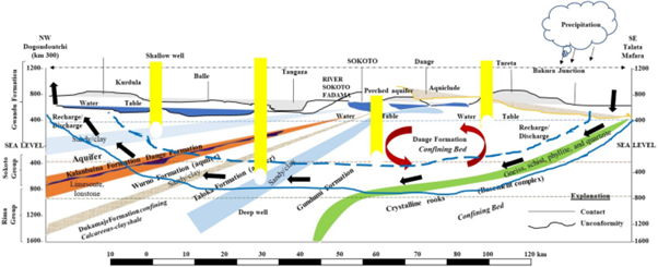
Figure 3 Hydrogeological cross-section of the Sokoto basin, NW Nigeria, illustrating primary confining beds and groundwater aquifers in the study area.53
This paper employed hydrogeological data, comprised of static water level, pumping water level, pumping test and estimated yield derived from 612 boreholes. Data were obtained from the Department for Rural Water Supply and Sanitation archive, Birninkebbi (RUWASSA). In the basement complex section, data were acquired from 103 boreholes, 113 boreholes in the central Sokoto basin, and 396 boreholes in the western Sokoto basin.
Statistical analysis
This paper employed basic statistics (Min, Max, and Mean) to summarise and standardise data. Six hundred twelve observations on Swl, Pt, Pwl, and Ey were made from 612 boreholes used in factor analysis and hierarchical cluster analysis. Factor analysis (FA) was used to study the relationships between the studied variables by reducing the multifaceted data to a more easily interpretable form.23 In this paper, FA was carried out on hydrogeological data: static water level (Swl), pumping water level (Pwl), pumping test (Pt) and estimated yields (Ey) from the Basement Complex section Central and Western Sokoto basin. In addition, FA was performed on a subset of 4 selected hydrogeological variables, which characterised the overall groundwater condition in the Sokoto basin.
Hierarchical cluster analysis was further carried out to gain an ultimate understanding of the hydrogeological condition of groundwater in the Sokoto basin by discretisation of boreholes into distinctive groups. In clustering, boreholes with similar hydrogeological properties or otherwise boreholes with distinctive properties would be grouped into identical clusters.45 In this paper, Ward's-algorithmic clustering technique after the Euclidean distance technique was used. This is considered the most potent grouping tool45,46 because it is capable of minimising the misrepresenting effect of the sum of squared distances of centroids from two theoretical groups produced at each step.
Therefore, applying factor scores into HCA is an outstanding technique for data interpretation by simplifying groupings into more communicative form, despite the ignorance of specific theoretically meaningful hydrogeological data.21 However, this technique does not account for data authenticity and disconnected values and neglects credible and possible connections or resemblances (statistical meddling) between hydrogeological variables, which are somewhat clear in most hydrogeological data.21 As a result, the output would have been inevitable to manipulation and not considered complete hydrogeological expressive data. Therefore, in this paper, we include only raw data into the HCA, where detailed examination on each grouping is achievable and tangible (without modification) conditions of hydrogeological conditions were characterised.21 Lastly, since the FA and HCA analyses can only indicate the variability between variables, a general regression model was generated using MINITAB (mbt 16) statistical software to determine the primary hydrogeological variable(s) influencing groundwater availability and accessibility in the Sokoto basin. As a result, estimated yield was chosen as a response variable, while standing water level, pumping water level, and pumping test were predictors.
Sokoto basin is divided into the sedimentary and crystalline basement complex sections. However, the sedimentary section was further subdivided into central and western Sokoto basins owing to its geographical extents. This allows for both geological and geographical (spatial) analyses. The western Sokoto basin occupies most parts of Kebbi State. The central Sokoto basin occupies the present Sokoto State. The Basement complex section covers some parts of the southwestern and eastern Sokoto basin (Zamfara State).
The crystalline basement complex section of the sokoto basin
The basement complex section of the basin occurs in the east (Gusau-Mafara axis) and southwest (Zuru-Yauri axis). Groundwater condition in this area is characteristic of the basement complex of Nigeria. Table 1 summarises hydrogeological variables: static water level, pumping water level, pumping test and estimated yields from boreholes in the basement complex. Evaluations from 113 boreholes indicate that Swl varies between 2.3m to 3m with a mean value of 11.7m. The pumping water level also varies significantly, with a mean Pwl value of 34.8m. The pumping test varies between 5.4 to 39 litres per minute (Lpm) with a mean Pt value of 18.9 Lpm. Estimated yields vary from 6 to 400 Lpm.
|
Parameter |
Basement complex (n=113) |
Central (n=103) |
Western (n=396) |
||||||
|
Min |
Max |
Mean |
Min |
Max |
Mean |
Min |
Max |
Mean |
|
|
Static Water Level |
2.3 |
31 |
11.7 |
3.6 |
74.6 |
38.9 |
0.2 |
70 |
19.5 |
|
Pumping Water Level |
4 |
150 |
34.8 |
10 |
180 |
46.6 |
6 |
180 |
53.5 |
|
Pumping Test |
5.4 |
39 |
18.9 |
4.7 |
199 |
44.5 |
1.2 |
78.4 |
23.6 |
|
Estimated Yields |
6 |
400 |
143.8 |
14 |
400 |
302.4 |
10 |
400 |
255.6 |
Table 1 Variability of hydrogeological parameters from boreholes in Sokoto basin
Groundwater under the basement complex section of the basin is generally available in small quantities from fissures or other tabular partings and the regolith (worn rock) just underneath the ground surface. The fissures are typically found above a depth of 91.44m; even so, yields to boreholes are relatively low and cause high drawdowns. For example, previous assessments of hydrogeological data on 70 boreholes in the basin discovered a mean borehole yield of 880 gallons per day (gph) from a mean depth of 37.49m.2 However, few boreholes in the unweathered rock, typically granite or gneiss, produced more than a meagre amount of water; in 23 boreholes, no water was found.
Conversely, boreholes tapping weathered granite and gneiss, where saturated, usually yielded the highest yield (~3,100 gph); the average yield for boreholes tapping regolith aquifer was 1,400 gph per borehole.2 In the same vein, Offodile4 reported that boreholes tapping the groundwater areas are the weathered and fractural zones in the formation. Just after Gusau, at kilometre 37 before Mafara, three test holes penetrated from 30-45m into granite run into the water table at about 10m. Generally, the borehole yield was better in the metasediments with splintered quartzites. Another borehole (45m depth) was less productive (0.8 lit/sec) and a steep-drawdown of 18m after 8hr pumping trailed by consequent waning in yield to 0.5 lit/sec.4 This type of poor yield is characteristic of boreholes in the basement complex section of the Sokoto basin. Such low yield zone results from aquifers of weathered or fractured rocks, with limited areal scope, such that during pumping or borehole development, the spreading cone of depression hits the highly indurated frontier rocks in a short time.4 The water level, or the drawdown, drops sharply and consistently decreases yield. High yields can be attained in some areas in the basement, contingent on the tectonics in those areas.
The lithology of part of the basement complex section of the Sokoto basin, as illustrated in Figure 4a, showed that the borehole at Yandu penetrated a weathered basement section (regolith) and is characterised by coarse sand, gravel, and clay. Groundwater can be obtained in reasonable quantities in the regolith aquifer. However, since these aquifers are limited to area, large drawdowns can affect the water yield. This borehole was screened at 22m, indicating a shallow water table that other environmental factors influence. The static water table (Swl) was 14m, and Pwl was 16m with an estimated yield (Ey) of 84 Lmp. Conversely, at Dankolo (Figure 4b), the borehole depth is less than 30m and is characterised by granite and gneiss with quartz veins of varying degrees of decomposition, which are overlain by lateritic clay and sand. The Swl was 4.4m, Pwl 15.3Lpm, and Ey 43 Lpm. Comparatively, the weathered section at Yandu is more water yielding. Despite the poor yields, boreholes in basement complex areas are sufficient to sustain hand pumps in rural water supply programmes. Figure 4(a-d) illustrates the variability of Swl, Pwl, Pt and Ey in the basement complex section of the Sokoto basin. Since groundwater condition in this area is typical of the basement complex areas of Nigeria, there is no need for further analysis.47–50
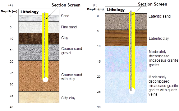
Figure 4 Type section of Boreholes in Basement complex section of Sokoto basin (A) Yandu and (B) Dankolo.
The central sokoto basin
The hydrogeological parameters from 113 boreholes in the central Sokoto basin (CSB) showed a marked spatial variability. Table 1 mean Swl was 38.9m and varied between 3 to 74m. The Pwl was 4.6.6 and ranged from 10 to 180m. The pumping test also varies from 4.7 to 199m with a mean Pt value of 44.5m. The Ey was 302.4 and varied from 14 to 400 Lpm. The spatial variability of Swl, Pwl, Pt, and Ey are illustrated in Figure 5. The lithological physiognomies were highly variable. At Bengaje (Borehole 28 SE – 1)- Figure 6a, the Swl is found at 37m, and Pt was 16 Lpm. The well was screened at 42m. In a similar borehole at Bengaje (28 SE – 2), Swl occurred at 34m, and Pt was comparable to SE – 1 (16 Lpm). The Pwl was also comparable to SE- 1 (34m). The Ey was higher (175Lpm) compared to SE -1. This well was screened at 39m below the surface. The lithology was generally similar.
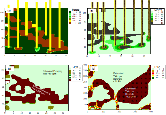
Figure 5 Variability of hydrogeological parameters in basement complex section of Sokoto basin (a) Static water level, (b) Pumping water level, (c) Pumping test and (d) Estimated yields.
Figure 6 At Yanakanari village (Borehole 28 NE-8)- Figure 6b, the drilling stopped at 42m, and the Swl was found at 20m below the surface. The Pt was carried out at 26m which varied with Pwl (20m). The Ey was 400 Lpm, and the well was screened at 24m. The variability of static water level, pumping test, pumping water level and estimated yields in the central Sokoto basin are summarised in Figure 7. The static water level in the central Sokoto basin ranges from 3.6 to 74.6m with a mean Swl of 38.9m. A pumping test was carried out from as low as 10m to over 180m below the ground surface. The pumping water level is highly variable and ranges from 4.7m to over 200m. The mean borehole yield is 302 Lpm and varies from 14 to 400 Lpm. Generally, boreholes in the central Sokoto basin are screened at an average depth of about 45m Figure 7.
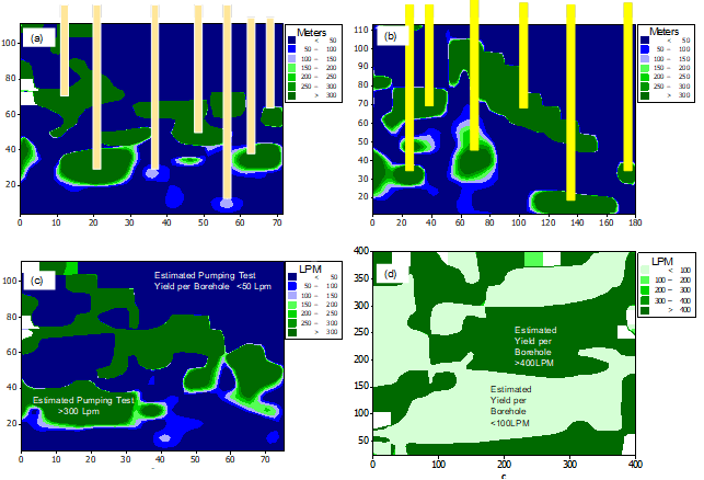
Figure 7 Variability of hydrogeological parameters in central Sokoto basin (a) Static Water Level, (b) Pumping Water level, (c) Pumping Test and (d) Estimated Yields.
Western sokoto basin
A total of 396 boreholes were studied in the western Sokoto basin. The Swl ranged from 0.2 to 70m with a mean Swl of 19.5m. Pumping water levels ranged from 6 to 180m with a mean value of 53.5m. Also, Pt varies between 1.2 to 78.4 Lpm with a mean of 23.6 Lpm. The Ey was 255.6m and ranged from 10 to 400m (Table 1). The western Sokoto basin predominantly consists of sands of varied sizes with some confining clay layers. For example, at Belin Zumbai (Figure 8a), in Borehole 48 SE-16, clay formations dominate sands. However, a few kilometres away, at Marake in Borehole 48 NE-17 (Figure 8b), the limestone layer (perhaps Kalambaina Formation) was encountered at about 49m beneath the ground.
Variability of hydrogeological parameters in the western Sokoto basin is illustrated in Figure 9. The Swl ranged from less than 1m to over 70m with a mean level of 19.5m. The pumping test is also exceedingly variable and ranges from 6 to 180 Lpm with a mean value of 53.5Lpm. Similarly, the pumping water level showed marked variability between the analysed boreholes. Mean Pwl was 23.6m and ranged from less than 2m to over 78m. Mean Ey was 255.6 Lpm and varied markedly between boreholes ranging from 10 to 400 Lpm. Current findings are comparable to other basins within Africa and beyond. Africa's groundwater storage was estimated to be 0.66 million km2. Although not all the stored groundwater is extractable, the predictable volume is more than 100 times the continent's estimated yearly renewable freshwater resources. The distribution of groundwater is highly variable, and the most significant volumes are observed in the sedimentary aquifers in North Africa.51 Areas having higher borehole yields (more than 51 litres per second) are limited. In the Cretaceous and Tertiary aquifers of the Kalahari Basin, the sandstones and calcareous sands constituted the major aquifer concerning higher sustained groundwater yields.52 Though good groundwater potentials characterise the global sedimentary aquifers, they are threatened by pollution and lowering of the water table due to environmental change and increased groundwater withdrawals.
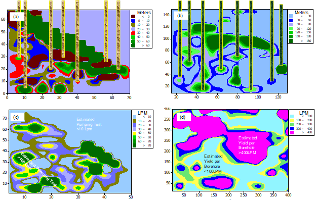
Figure 9 Variability of hydrogeological parameters in western Sokoto basin (a) Static Water level, (b) Pumping Water Level, (c) Pumping Test and (d) Estimated Yield.
Statistical application
Factor analysis
Factor analysis was carried out on 612 boreholes to evaluate the interrelationships within the hydrogeological data by reducing the complex information to an easily interpretable form. FA results comprising the loadings, eigenvalues, and percentages of total variance are presented in Table 2. The extraction of 3 factors was built on the proportion of variance accrued, including a percentage greater than 80%.23 The computed data indicate that these three factors explained 96.20 % of the total variance. Based on the 'scree test', the three factors with typical factor loadings suggest the three different noticeable contributions were involved in controlling the hydrogeology of the Sokoto basin. Factor 1 explained 48.33% of the total variance and had high positive loading on Swl and Pwl, associated with boreholes in the western Sokoto basin. Western Sokoto basin had better aquifers (notably Gwandu Formation).
|
Parameters |
Factor 1 |
Factor 2 |
Factor 3 |
|
Static water level |
0.909 |
-0.304 |
-0.081 |
|
Pumping test |
0.403 |
0.767 |
0.498 |
|
Pumping water level |
0.83 |
-0.473 |
0.139 |
|
Estimated yield |
0.506 |
0.712 |
-0.479 |
|
Eigenvalues |
1.812 |
1.03 |
1.006 |
|
% of Variance |
48.334 |
35.298 |
12.575 |
|
Cumulative % |
48.334 |
83.632 |
96.208 |
Table 2 Factor scores (Varimax rotation) of hydrogeological parameters
Factor 2, which explained 35.29% of the total variance, can be associated with boreholes in the central Sokoto basin and had high positive loadings on Pt and Ey. The Central Sokoto basin is characterised by prolific aquifers (Gundumi and Kalambaina Formations). The Kalambaina Formation is the most critical aquifer in Sokoto town and is heavily exploited for municipal water supply.2 Factor three explained 12.57% of the total variance and has high positive loading on Pt. Perhaps this Factor is associated with the basement complex section of the Sokoto basin, where boreholes are often characterised by poor yields even though high yields can be obtained, after which high drawdown is recorded.4
Hierarchical cluster analysis
The graphics collections of the clustering process of hydrogeological variables are presented as a dendrogram (Figure 10). Based on the dendrogram, boreholes with similarities are mainly collected into three different groups. The first cluster (group 1) constituted boreholes with higher Swl and Pt. The lithology here essentially comprises sand and clay of Gwandu and Illo Formations. The second cluster was constituted of boreholes having a higher level of pumping test. The lithology is characterised by sand, clay, and limestone of Gundumi, Wurno, and Kalambaina Formations. The third cluster was comprised of boreholes having very high yields. Their lithology is a mixture of lithological characteristics of both the central and western Sokoto basins. Generally, the studied boreholes in the three groups were characterised by high-medium and poor water yields. Although both clusters, 1 and 3, are referred to as geologic or aquifer wells, boreholes in the central Sokoto basin demonstrated hydrogeological conditions similar to those in the western Sokoto basin. Both central and western Sokoto basins are of the same geological setting. As a result, their groundwater condition must be similar, even with geographical variability.4
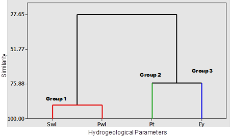
Figure 10 The dendrogram was produced from cluster analysis based on the analysed boreholes to recognise the significant hydrogeological Physiognomies in the Sokoto basin. Three major groups were distinguished: Group 1 (Swl, Pwl); Group 2 (Pt); and Group 3 (Ey).
Regression analysis
Though both the FA and HCA analyses can only indicate the variability of hydrogeological conditions between the three sections of the basin, a result, a general regression model was generated using MINITAB (mbt 16) statistical software in order to find out the primary hydrogeological parameter(s) influencing groundwater condition in Sokoto basin. Therefore, Ey was the response variable, while Swl, Pwl, and Pt were predictors. As a result, as summarised in Table 3, the model shows that Swl is the most influential hydrogeological variable influencing groundwater conditions in the basin.
|
Summary of model |
S |
R-Sq% |
Rsq (Adj)% |
|||
|
147.98 |
66.78 |
18.94 |
||||
|
Analysis of Variance |
||||||
|
Source |
DF |
Seq SS |
Adj SS |
Adj MS |
F |
P |
|
Regression |
180 |
5495648 |
5495648 |
30531.4 |
1.39593 |
0.023398 |
|
Static water level |
180 |
5495648 |
5495648 |
30531.4 |
1.39593 |
0.023398 |
|
Error |
125 |
2733968 |
2733968 |
21871.7 |
||
Table 3 Summary of the general regression model
The residual plot for the estimated yield in the Sokoto basin, as presented in Figure 11, was used to verify the hypothesis that residuals are normally distributed. The normal probability plot of the residuals should approximately follow a straight line, as indicated in Figure 10a. When the plot shows a non-normal pattern, other residual plots (Figure 10b-d) can be used to check for other problems with the model, such as missing terms or a time order effect. Prediction intervals can be inaccurate if the residuals do not follow a normal distribution. If the residuals do not follow a normal distribution and the statistics have more minor observations (n=<15), then confidence intervals for predicting p-values for coefficients can be inaccurate. The observed normality in this analysis confirms the accuracy of the general regression model used.
The importance of understanding the relationship between geology and groundwater availability and accessibility is unanimously agreed upon in the literature. This study has indicated our novel efforts to understand better the link between groundwater availability and geological setting from the Sokoto basin. Understanding the relationship between these components is essential for utilising groundwater resources. This study found that:
Nevertheless, this study presents only a spatial assessment. Therefore, comprehensive studies comparing groundwater with geology over broader spatial and temporal scales are recommended.54–60
Federal University Birnin kebbi supported this study. The Department for Rural Water Supply and Sanitation Birnin-kebbi provided data. Our sincere thanks to Umar Ishaku, former Head of Geology Unit.
The author declares there is no conflict of interest.

©2022 Wali, et al. This is an open access article distributed under the terms of the, which permits unrestricted use, distribution, and build upon your work non-commercially.