eISSN: 2576-4500


Mini Review Volume 9 Issue 2
1Information and Communications Engineering Department, Usmanu Danfodiyo University, Sokoto, Nigeria.
2Engineering and Design Department, School of Engineering and Informatics, University of Sussex, Brighton, United Kingdom.
Correspondence: Lasisi Salami Lawal, Information and Communications Engineering Department, Usmanu Danfodiyo University, Sokoto, Nigeria, Tel +2348023151587
Received: March 23, 2025 | Published: April 22, 2025
Citation: Lawal LS, Chatwin CR. Need For GNSS policy to help fast-track implementation of continent- wide satellite-based augmentation system (SBAS) for Africa. Aeron Aero Open Access J. 2025;9(1):79-86. DOI: 10.15406/aaoaj.2025.09.00223
Satellite-Based Augmentation System (SBAS) deployment on a continental level would allow for CAT-I approaches on all runway ends, greatly enhancing the safety and operational efficiency in the approach phase. The aerospace sector is a critical component of Africa’s economy, connecting people, goods, and services across the nations, regionally and globally. However, the current navigation infrastructure particularly category 3 level of Instrument Landing Systems (ILS) faces challenges in meeting the increasing navigation demands beyond the major cities in Africa for safety, efficiency, and precision in aviation operations.
The article provides SBAS service demonstrations in some African countries including Nigeria, benefits of Satellite-Based Augmentation Systems (SBAS), coupled with a well-structured Global Navigation Satellite System (GNSS) policy to offer transformative potential for addressing these challenges.
Keywords: cost benefit analysis, GNSS policy, ICAO SARPs, SBAS for Africa
Satellite-Based Augmentation System (SBAS) enhances and improves the accuracy, integrity, and availability of Global Navigation Satellite System (GNSS) signals, like GPS, Galileo, Beidou by providing wide-area corrections data and range errors via geostationary satellites.1–10
SBAS-supported operations provide more safety, enhanced navigation effectiveness, and contribute to reducing operational costs for airlines, while improving accessibility to local airports, runways in remote and mineral-rich states facilitating investments among others.
The aerospace sector is a critical component of Africa’s economy, connecting people, goods, and services across the nations, regionally and globally. However, the current navigation infrastructure particularly category 3 level of Instrument Landing Systems (ILS) faces challenges in meeting the increasing navigation demands beyond the major cities in Africa for safety, efficiency, and precision in aviation operations. Satellite-Based Augmentation Systems (SBAS), coupled with a well-structured Global Navigation Satellite System (GNSS) policy, offer transformative potential for addressing these challenges.
African aviation stakeholders and non-aviation stakeholders in general must define the governance structure and model of Satellite Based Augmentation System (SBAS) in Africa in complementary role to exiting navigation technologies in aviation and non-aviation sectors of African Economy.11–14
SBAS adoption in Aviation sector in Africa aligns with the Single African Air Transport Market (SAATM) agenda of African Union (AU); a flagship project of the AU agenda 2063 to advance the liberalization of civil aviation in Africa through a unified sky and acting as an impetus to the continent’s economic integration agenda.
The implementation of Satellite-Based Augmentation Systems (SBAS) in the aerospace sector is pivotal for enhancing aviation safety and operational efficiency in all parts of Africa where rural or domestic airports beyond the major cities. SBAS enhances the Global Navigation Satellite System (GNSS) by providing critical corrections and integrity monitoring, which are essential for safety-critical applications in aviation. The primary function of SBAS is to improve the accuracy, integrity, and availability of GNSS signals, which is crucial for navigation and landing procedures in civil aviation.
SBAS operates by utilizing geostationary satellites to transmit correction data to GNSS users. This capability significantly enhances the quality of GNSS positioning, making it suitable for various civil aviation tasks, including precision approaches and landings. For instance, the European Geostationary Navigation Overlay Service (EGNOS) and the Wide Area Augmentation System (WAAS) have been instrumental in supporting aircraft navigation by providing reliable positioning information that meets stringent safety requirements. The integration of SBAS allows for advanced procedures such as Localizer Performance with Vertical Guidance (LPV), which provides pilots with critical guidance during approach and landing phases.
Moreover, the synergy between SBAS and other augmentation techniques, such as Ground-Based Augmentation Systems (GBAS) and Receiver Autonomous Integrity Monitoring (RAIM), further enhances the integrity of navigation systems. These systems work in tandem to ensure that any potential errors in GNSS signals are detected and mitigated, thereby safeguarding aviation operations from hazardous misleading information (HMI).The incorporation of multiple GNSS constellations and advanced monitoring techniques allows for improved fault detection and exclusion, which is essential for maintaining high safety standards in aviation.
The formulation of GNSS policy in the context of SBAS implementation is also critical. As countries develop their own SBAS, such as India's GAGAN and China's BeiDou SBAS, it becomes increasingly important for Nigeria as a Member-ready State for SAATM (Pilot Implementation Project (PIP) and other African countries to formulate GNSS policy in line with established international standards and protocols to ensure interoperability and safety across different GNSS systems to fast-track utilization as it concerns positioning, navigation and time across different sectors of our economy. The International Civil Aviation Organization (ICAO) plays a vital role in this regard, providing guidelines and frameworks for the integration of GNSS and augmentation systems in aviation sector.
GNSS policy formulation becomes a necessity arising from the dormancy of the Navigation resource onboard Nigerian Communications Satellite (NIGCOMSAT-1R) since the re-launch of the satellite 2011 until recently.
And moreso, borrowing from European Union (EU) strategic autonomy utilizing Space and GNSS policy. EU space programmes such as Copernicus, Galileo and European Geostationary Navigation Overlay Service (EGNOS) provide geo-localization and earth observation services strengthening the EU capacity to monitor and track transportation, provide precision agriculture, counter crimes, monitor greenhouse emissions, manage borders, develop its digital economy, provide weather forecast among others.15 In accordance with Regulation (EU) 2021/696 of 28 April 2021, establishing the Union Space Programme and the European Union Agency for the Space Programme, the mission as EU Space Law (EUSL) is to primarily provide safe and secure European satellite navigation services, advances the commercialization of Galileo, EGNOS, and Copernicus data and services, engages in secure SATCOM (satellite communications), and operate the EU Space Surveillance and Tracking (EU SST) Front Desk. The new EU Space Programme under The European Union Agency for the Space Programme (EUSPA) secures EU leadership in space activities, foster innovative industries, safeguard autonomous access to space and simplify governance with €13,2 billion funding to finance space activities from 2021 to 2027.16,17
As a matter of fact, Nigeria in conjunction with Thales Alenia Space (TAS) of France entered into agreement with the Agency for Air Navigation Safety in Africa and Madagascar (ASECNA) to conduct the first SBAS trial on the 27th of January 2021 with series of 5 real-flight SBAS demonstration utilizing ATR-42 Aircraft was conducted at Lomé International Airport through NIGCOMSAT-1R satellite as shown in Figure 1. Similarly, on 2nd June, 2021, A Helicopter demonstration flight was conducted along a low-level, two-way route linking two Point-in-Space (PinS) approaches to the Douala airport and a point near the oil platforms located on the Kribi coast, both in Cameroon as shown in Figure 2.
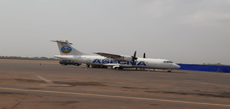
Figure 1 The fixed-wing aircraft; ATR-42 owned by ASECNA and used for the SBAS flight demonstration in Togo.
We also successfully demonstrated the additional services provided by SBAS on July 7 and 8, 2021 in Brazzaville, Congo in non-aviation sector specifically at the National Stadium Alphonse Massamba-Debat employing a dual-frequency GNSS chipset receiving GPS and Galileo signals as Navigation Overlay Service (NOS) via NIGCOMSAT-1R Navigation Payload as illustrated in Figure 3. The aim was to accelerate the development of additional satellite services for Africa and the Indian Ocean to deliver precise point positioning (PPP) and danger warnings for a wide range of applications in Africa. The transmission of GNSS (Global Navigation Satellite System) corrections based on PPS technology and also using the SBAS signal.18–22 This approach showed the system’s ability to achieve positioning accuracy to within centimeters across the entire African continent. A world first within the continent for broad range of application in various sectors, including precision agriculture, land and maritime transport, rail safety, drone navigation, mapping and surveying etc utilizing SBAS. The demonstration was realized after we commenced a Satellite-Based Augmentation System (SBAS) broadcast signal over Africa and the Indian Ocean (AFI) region on Thursday, 10th September, 2020 with a successful test bed Signal-in Space broadcasted through NIGCOMSAT-1R SBAS payload globally over Africa, Indian Ocean, West Australian coast and Europe with support from Europe for Francophone countries in Africa.
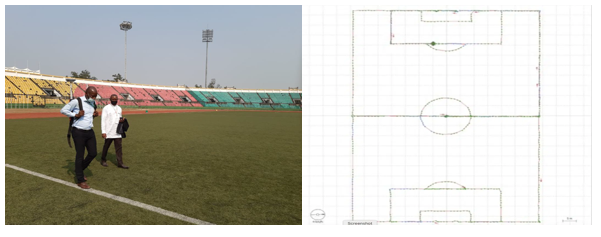
Figure 3 SBAS demonstration at Brazzaville, Republic of Congo between July 6 to 9, 2021in non-aviation sector delivering precise point positioning (ppp) to centimeter level.
After series of successful demonstrations outside the country and series of Memos to Ministry of Aviation, NIGCOMSAT Ltd received approval from Ministry of Aviation now Ministry of Aviation and Aerospace Development to conduct same flight demonstration within Nigerian airspace in conjunction with Nigerian Airspace Management Agency (NAMA) and Nigerian Civil Aviation Authority (NCAA). In 2023, Nigeria with the support of NIGCOMSAT LTD, Nigerian Airspace Management Agency (NAMA), Nigerian Civil Aviation Authority (NCAA) and international stakeholders ‘join words with actions’ on February 1st, 2023 using NAMA’s Beechcraft King Air 350i to demonstrate and showcase the capabilities of SBAS not only in Aviation sector but also non-Aviation sectors to drum up the required collective resources by stakeholders to adopt SBAS for its many benefits and applications on a continental scale with jointly organized outreach event on SBAS adoption in aviation in Africa on the 2nd and 3rd of February, 2023 in Abuja, Nigeria.
The then, President of Federal Republic of Nigeria urged Nigerian Communications Satellite (NIGCOMSAT) to collaborate with aviation sector in the 54 African countries towards a successful implementation of the Satellite Based Augmentation System (SBAS) for Africa. This is in line with outcome of African Union Commission (AUC) recommendation for which NIGCOMSAT Ltd as part of Nigeria’s delegation supported continent-wide SBAS in Africa during cost benefit analysis (CBA) of implementation of SBAS in the continent of Africa in Rwanda facilitated by Africa Union Commission (AUC) and African Civil Aviation Commission (AFCAC); the specialized agency for all civil aviation matters on the African continent. Figures 4–11 shows pictures of the SBAS flight demonstration and SBAS Workshop on Benefits to African aviation stakeholders.

Figure 5 Fixed-Wing aircraft owned by Nigerian airspace management agency used for real SBAS flight demo at Abuja international airport.
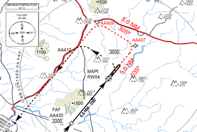
Figure 6 Designed and developed SBAS/LPV procedure using existing RNAV GNSS (GPS) procedure for Abuja international airport.

Figure 8 Invited dignitaries and one of the foremost SBAS pilot (certified Pilot for Kingair 350i Aircraft).
The GNSS Policy for Nigeria and other African countries will not only advocate for the adoption of SBAS to improve aviation safety, enhance efficiency in line with International Civil Aviation Organization (ICAO) standards and Recommended Practices (SARPs) Annex 10 Volume 1 as released in the 8th edition July, 2023 but will as well fast-track adoption and adaptation in non-aviation sector such as precision agriculture, survey, oil & gas, civil engineering, maritime, rail, road, location based services (LBS) and mass market applications. It underscores the urgent need for a comprehensive GNSS policy to streamline positioning, navigation and timing infrastructure and applications across Nigeria and beyond.
Main benefits in Aviation are CFIT reduction and Supporting Automatic Dependent Surveillance Broadcast (ADS-B) implementation. It also supports ground infrastructure representing the highest investment required in Africa and thus the cost benefit analyses (CBA) for an Inter-regional SBAS takes a more pragmatic approach with considered benefits that can be measured in financial terms accruing to the civil aviation sector. Cumulated benefits of SBAS for aviation in the AFI region over a 30-year period will amount to €1,650 million compared to expected investments of about €360 million. Discounted net benefits amount to €210 million, which makes it a hugely positive case for SBAS implementation in Africa. ASECNA is playing a big role as a key stakeholder in Africa’s aviation sector particularly in francophone countries.
The business case for the aviation sector conducted recently and presented at the Cost Benefit Analysis (CBA) on Implementation of SBAS in Africa at Kigali in 2022 shows high profitability with a 545% ROI, 36% IRR, NPV of 287 M$ by 2045 and a 6-year payback period while SBAS system’s implementation in Africa on a continental scale was also economically positive for all stakeholders under all the evaluated scenarios beyond aviation sector with a 402 M$ NPV at 2045, E-IRR of 28%, ROI of 110% and a 5-year payback period. The carbon footprint net emission savings amount to 1,424 million kg of CO2 over the analysis timeframe.
Many other regions of the continent already raised interest on SBAS such as South Africa, Eastern Africa etc and Nigeria through Ministry of Aviation and Aerospace Development and Nigerian Airspace Management Agency (NAMA) must spearhead and help define the way SBAS system, a new Performance–based Navigation (PBN) should be deployed at best for the needs of the continent and Anglophone countries in particular and thus widening the reach of NAMA beyond our nation’s airspace while NCAA as a matter of mandate continue to enhance and provide aviation safety and economic regulatory services in the most efficient, most effective, quality technologically- driven manner to the satisfaction and benefit of all stakeholders, consistent with highest international standards and sustainable development of the industry and national economy.23–30
Some operational benefits of SBAS
Other benefits of SBAS as it concerns improvement of safety and reduction in operational costs and environment:
General benefits
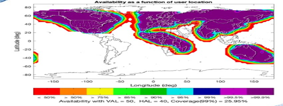
Figure 13 World SBAS coverage (African SBAS not operational except trial facilitated by Nigerian Satellite; NIGCOMSAT-1R).
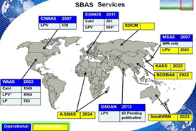
Figure 14 Operational and planned world SBAS coverage (African SBAS not operational except trial facilitated by Nigerian Satellite; NIGCOMSAT-1R).
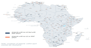
Figure 16 Gap assessment of GNSS infrastucture in Africa (Aviation sector: Current airport infrastructure & procedures) as at 2022.
Stakeholders are invited to note the followings:
Specialized institutions and partners in Africa are encouraged to undertake capacity building and awareness activities for the applications of SBAS in aviation and non-aviation sectors.
Conclusively, Implementing SBAS and formulating a GNSS policy represent vital steps toward transforming Nigeria’s aerospace sector and the Continent in general as it concerns the governance model initiative for African Union (AU). This initiative will enhance safety, improve operational efficiency, and position Nigeria as a leader in aviation innovation within the continent.
Future scope for a start in a bid to bridge the GNSS policy vacuum in transportation sector in particular (Aerospace, other transport sectors) should be formulation of a National GNSS Policy Committee aimed at repositioning Nigeria as a prime global investment destination which aligns with well-thought-out plan of Federal Government of Nigeria in adding aerospace development portfolio to the ministry of aviation. Membership and representatives may include but not limited to the followings:
Proposed terms of reference (TOR) includes but not limited to the followings:
None.
The authors declare that there are no conflicts of interest.
None.

©2025 Lawal, et al. This is an open access article distributed under the terms of the, which permits unrestricted use, distribution, and build upon your work non-commercially.